
Thank you for supporting this site ❤️
Make a donation
Make a donation
Bonga topographic map
Click on the map to display elevation.
Thank you for supporting this site ❤️
Make a donation
Make a donation
Bonga
Bonga is a town, woreda and one of the multicapital of the South West Ethiopia Peoples' Region in Ethiopia. Located in the Keffa Zone upon a hill in the upper Barta valley, it has a latitude and longitude of 7°16′N 36°14′E / 7.267°N 36.233°E / 7.267; 36.233 with an elevation of 1,714 meters above sea level. Not confused with another town named "Bonga", near Gambela Region.
Thank you for supporting this site ❤️
Make a donation
Make a donation
About this map
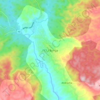
Name: Bonga topographic map, elevation, terrain.
Location: Bonga, Keffa, South West Ethiopia Peoples, Ethiopia (7.22454 36.20605 7.30454 36.28605)
Average elevation: 1,769 m
Minimum elevation: 1,575 m
Maximum elevation: 2,050 m
Thank you for supporting this site ❤️
Make a donation
Make a donation