
Thank you for supporting this site ❤️
Make a donation
Make a donation
Vale topographic map
Click on the map to display elevation.
Thank you for supporting this site ❤️
Make a donation
Make a donation
Vale
According to the United States Census Bureau, the city has a total area of 1.14 square miles (2.95 km2), all of it land. The city has an elevation of 2,244 feet (684 m) above sea level.
Thank you for supporting this site ❤️
Make a donation
Make a donation
About this map
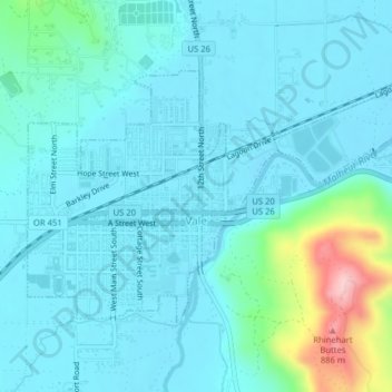
Name: Vale topographic map, elevation, terrain.
Location: Vale, Malheur County, Oregon, United States (43.97467 -117.25552 43.99298 -117.21592)
Average elevation: 710 m
Minimum elevation: 677 m
Maximum elevation: 897 m
Thank you for supporting this site ❤️
Make a donation
Make a donation