
Thank you for supporting this site ❤️
Make a donation
Make a donation
Rastede topographic map
Click on the map to display elevation.
Thank you for supporting this site ❤️
Make a donation
Make a donation
About this map
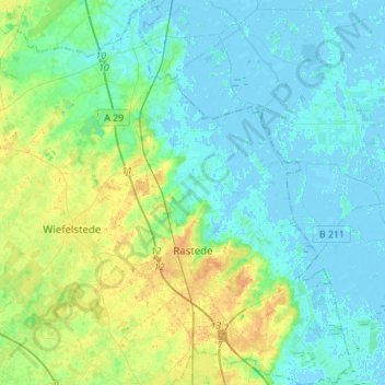
Name: Rastede topographic map, elevation, terrain.
Location: Rastede, Landkreis Ammerland, Nedersaksen, 26180, Duitsland (53.18890 8.10537 53.35415 8.31573)
Average elevation: 7 m
Minimum elevation: -4 m
Maximum elevation: 25 m
Thank you for supporting this site ❤️
Make a donation
Make a donation
Other topographic maps
Click on a map to view its topography, its elevation and its terrain.