
Municipal Unit of Sikyona topographic map
Interactive map
Click on the map to display elevation.
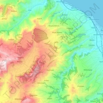
Municipal Unit of Sikyona topographic map, elevation, terrain
About this map
Name: Municipal Unit of Sikyona topographic map, elevation, terrain.
Average elevation: 478 m
Minimum elevation: 0 m
Maximum elevation: 1,334 m
Other topographic maps
Click on a map to view its topography, its elevation and its terrain.
Municipal Unit of Vocha
Greece > Peloponnese, Western Greece and the Ionian > Corinthia Regional Unit
Average elevation: 203 m
Corinth
Greece > Peloponnese, Western Greece and the Ionian > Corinthia Regional Unit
Average elevation: 185 m