
Make a donation
Solok topographic map
Click on the map to display elevation.
Make a donation
Solok
Solok (means valley) is a city in West Sumatra, Indonesia. The motto of this city is Kota Beras which is an abbreviation of "Bersih, Elok, Rapi, Aman dan Sejahtera". It has an area of 58.72 km2 (0.14 percent of the area of West Sumatra), a population of 59,396 at the 2010 Census, and 73,438 at the 2020 Census; the official estimate as at mid-2022 was 75,850 - comprising 38,231 males and 37,619 females. Solok topography varies between the plains and hilly with a height of 390 m above sea level. Three tributaries cross Solok, namely Batang Lembang, Batang Gawan, and Batang Air Binguang.
Make a donation
About this map
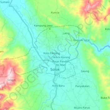
Name: Solok topographic map, elevation, terrain.
Location: Solok, West Sumatra, Sumatra, Indonesia (-0.81905 100.54147 -0.74142 100.68534)
Average elevation: 562 m
Minimum elevation: 339 m
Maximum elevation: 1,287 m
Make a donation
Other topographic maps
Click on a map to view its topography, its elevation and its terrain.
Make a donation
Make a donation
Make a donation
Make a donation
Make a donation
Make a donation
Make a donation
Make a donation
Make a donation
Make a donation
Make a donation
Make a donation
Make a donation
Make a donation
Make a donation
Make a donation
Make a donation
Make a donation
Make a donation