
Thank you for supporting this site ❤️
Make a donation
Make a donation
Cabadbaran topographic map
Click on the map to display elevation.
Thank you for supporting this site ❤️
Make a donation
Make a donation
Cabadbaran
It is generally flat with rolling hills and swamplands in its western part. The highest of all mountains in the Caraga region, Mount Hilong-Hilong (with an altitude of 2,012 metres (6,601 ft) above sea level), rises in this city.
Thank you for supporting this site ❤️
Make a donation
Make a donation
About this map
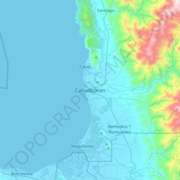
Name: Cabadbaran topographic map, elevation, terrain.
Location: Cabadbaran, Agusan del Norte, Caraga, 8605, Philippines (8.96329 125.37223 9.28329 125.69223)
Average elevation: 179 m
Minimum elevation: -2 m
Maximum elevation: 1,751 m
Thank you for supporting this site ❤️
Make a donation
Make a donation
Other topographic maps
Click on a map to view its topography, its elevation and its terrain.