
Annapurna topographic map
Interactive map
Click on the map to display elevation.
About this map
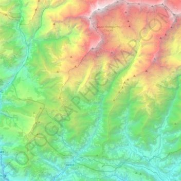
Name: Annapurna topographic map, elevation, terrain.
Location: Annapurna, कास्की, Gandaki, 33711, Népal (28.25514 83.69944 28.61295 83.94755)
Average elevation: 2,974 m
Minimum elevation: 747 m
Maximum elevation: 8,013 m
Other topographic maps
Click on a map to view its topography, its elevation and its terrain.
Khumai Dada
Khumai Dada, Mardi Himal East ascent trail, Machhapuchchhre-01, Machhapuchchhre, कास्की, Gandaki, Népal
Average elevation: 2,813 m
Dhampus Phedi
Dhampus Phedi, Machhapuchchhre, कास्की, Gandaki, Népal
Average elevation: 1,475 m
Mardi Himal
Mardi Himal, Machhapuchchhre, कास्की, Gandaki, Népal
Average elevation: 4,967 m