
New London County topographic map
Interactive map
Click on the map to display elevation.
About this map
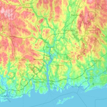
Name: New London County topographic map, elevation, terrain.
Location: New London County, Connecticut, United States of America (41.27132 -72.46673 41.71441 -71.78764)
Average elevation: 75 m
Minimum elevation: -3 m
Maximum elevation: 252 m
Other topographic maps
Click on a map to view its topography, its elevation and its terrain.
Hartford
United States of America > Connecticut > Hartford
Hartford, Hartford County, Connecticut, United States of America
Average elevation: 23 m
Hartford County
United States of America > Connecticut
Hartford County, Connecticut, United States of America
Average elevation: 122 m
New Haven
United States of America > Connecticut > New Haven
New Haven, New Haven County, Connecticut, United States of America
Average elevation: 20 m