
Thank you for supporting this site ❤️
Make a donation
Make a donation
Grone topographic map
Click on the map to display elevation.
Thank you for supporting this site ❤️
Make a donation
Make a donation
About this map
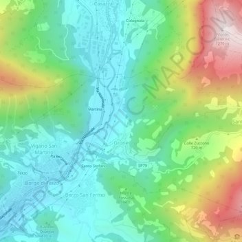
Name: Grone topographic map, elevation, terrain.
Location: Grone, Bergamo, Lombardy, 24060, Italy (45.71666 9.90196 45.74507 9.95599)
Average elevation: 585 m
Minimum elevation: 284 m
Maximum elevation: 1,267 m
Thank you for supporting this site ❤️
Make a donation
Make a donation
Other topographic maps
Click on a map to view its topography, its elevation and its terrain.
Thank you for supporting this site ❤️
Make a donation
Make a donation
Thank you for supporting this site ❤️
Make a donation
Make a donation
Thank you for supporting this site ❤️
Make a donation
Make a donation