
Mason Island topographic map
Interactive map
Click on the map to display elevation.
About this map
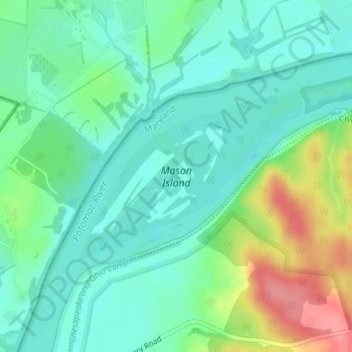
Name: Mason Island topographic map, elevation, terrain.
Location: Mason Island, Montgomery County, Maryland, United States (39.16935 -77.51496 39.18294 -77.49245)
Average elevation: 78 m
Minimum elevation: 53 m
Maximum elevation: 136 m
Other topographic maps
Click on a map to view its topography, its elevation and its terrain.
Rockville
United States > Maryland > Montgomery County
Rockville, Montgomery County, Maryland, United States
Average elevation: 122 m
Fairland
United States > Maryland > Montgomery County
Fairland, Montgomery County, Maryland, United States
Average elevation: 111 m
Germantown
United States > Maryland > Montgomery County
Germantown, Montgomery County, Maryland, 20874, United States
Average elevation: 136 m
Derwood
United States > Maryland > Montgomery County
Derwood, Montgomery County, Maryland, 20855, United States
Average elevation: 133 m
Randolph Hills
United States > Maryland > Montgomery County > North Bethesda
Randolph Hills, North Bethesda, Montgomery County, Maryland, 20896, United States
Average elevation: 98 m
White Oak
United States > Maryland > Montgomery County > White Oak
White Oak, Montgomery County, Maryland, 20993, United States
Average elevation: 101 m
Gaithersburg
United States > Maryland > Montgomery County
Gaithersburg, Montgomery County, Maryland, United States
Average elevation: 137 m
Burnt Mills Village
United States > Maryland > Montgomery County > Burnt Mills
Burnt Mills Village, Burnt Mills, Montgomery County, Maryland, 20901, United States
Average elevation: 104 m
Seneca Park
United States > Maryland > Montgomery County > Montgomery Village
Seneca Park, Montgomery Village, Montgomery County, Maryland, 20876, United States
Average elevation: 124 m
Hickory Ridge
United States > Maryland > Montgomery County > Damascus
Hickory Ridge, Damascus, Montgomery County, Maryland, 20872, United States
Average elevation: 196 m
Lock 22: Pennyfield Lock
United States > Maryland > Montgomery County > Travilah
Lock 22: Pennyfield Lock, Estates at Rivers Edge, Travilah, Montgomery County, Maryland, United States
Average elevation: 73 m
Bethesda
United States > Maryland > Montgomery County
Bethesda, Montgomery County, Maryland, United States
Average elevation: 81 m
Potomac
United States > Maryland > Montgomery County > Potomac
Potomac, Montgomery County, Maryland, 20854, United States
Average elevation: 86 m
North Bethesda
United States > Maryland > Montgomery County > North Bethesda
North Bethesda, Montgomery County, Maryland, United States
Average elevation: 98 m
Burtonsville
United States > Maryland > Montgomery County > Burtonsville
Burtonsville, Montgomery County, Maryland, 20866, United States
Average elevation: 119 m