
Thank you for supporting this site ❤️
Make a donation
Make a donation
Rustenburg topographic map
Click on the map to display elevation.
Thank you for supporting this site ❤️
Make a donation
Make a donation
Rustenburg
Rustenburg has a humid subtropical climate (Köppen Cwa), with a relatively high degree of diurnal temperature variation due to the high elevation. It has very warm summers (from December to February) and mild winters (from June to August). Due to the altitude, summers are not quite as hot as one might expect. Precipitation occurs mainly in summer. There is occasional frost at night in winter.
Thank you for supporting this site ❤️
Make a donation
Make a donation
About this map
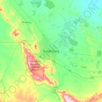
Name: Rustenburg topographic map, elevation, terrain.
Average elevation: 1,217 m
Minimum elevation: 1,028 m
Maximum elevation: 1,756 m
Thank you for supporting this site ❤️
Make a donation
Make a donation