
Make a donation
Norwood topographic map
Click on the map to display elevation.
Make a donation
About this map
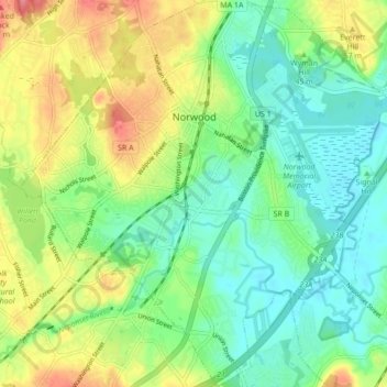
Name: Norwood topographic map, elevation, terrain.
Location: Norwood, Norfolk County, Massachusetts, 02062, United States (42.14992 -71.23834 42.21388 -71.15485)
Average elevation: 37 m
Minimum elevation: 8 m
Maximum elevation: 90 m
Make a donation
Other topographic maps
Click on a map to view its topography, its elevation and its terrain.
Weymouth Woods
United States > Massachusetts > Norfolk County > Weymouth > South Weymouth > Pine Grove
Average elevation: 49 m
Make a donation
Make a donation
Charles River Village
United States > Massachusetts > Norfolk County > Needham
Average elevation: 49 m
Make a donation
Make a donation
Make a donation
Make a donation
Lake Massapoag
United States > Massachusetts > Norfolk County > Sharon
Because of the lake and the fact that Sharon is at a slightly higher elevation than the surrounding towns, and because it is located on the main rail line going south from Boston, the shores of the lake developed into a minor summer resort with several large hotels, summer camps and cottage colonies. Temple…
Average elevation: 84 m
Make a donation
Make a donation
Make a donation
Make a donation
Wellesley Farms
United States > Massachusetts > Norfolk County > Wellesley > Wellesley Farms
Average elevation: 48 m
Make a donation