
Mauna Kea topographic map
Interactive map
Click on the map to display elevation.
About this map
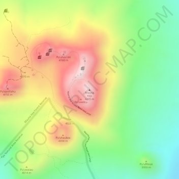
Name: Mauna Kea topographic map, elevation, terrain.
Location: Mauna Kea, Hawaiʻi County, Hawaii, United States (19.82061 -155.46813 19.82071 -155.46803)
Average elevation: 3,978 m
Minimum elevation: 3,759 m
Maximum elevation: 4,209 m
With its high elevation, dry environment, and stable airflow, Mauna Kea's summit is one of the best sites in the world for astronomical observation. Since the creation of an access road in 1964, thirteen telescopes funded by eleven countries have been constructed at the summit. The Mauna Kea Observatories are used for scientific research across the electromagnetic spectrum and comprise the largest such facility in the world. Their construction on a landscape considered sacred by Native Hawaiians continues to be a topic of debate to this day.
Other topographic maps
Click on a map to view its topography, its elevation and its terrain.
Kilauea
United States of America (Island of Hawai'i territorial waters) > Hawaii > Hilo
Kilauea, Hilo, Hawaiʻi County, Hawaii, United States of America (Island of Hawai'i territorial waters)
Average elevation: 1,096 m