
霞ヶ関一丁目 topographic map
Interactive map
Click on the map to display elevation.
About this map
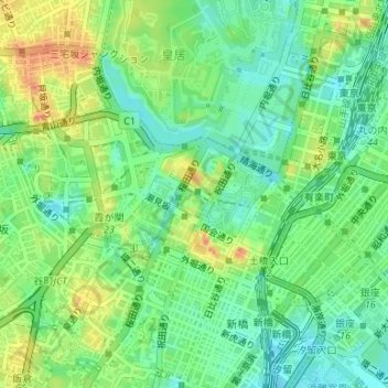
Name: 霞ヶ関一丁目 topographic map, elevation, terrain.
Location: 霞ヶ関一丁目, 霞ヶ関, 千代田区, Tokyo, 100-0013, Japon (35.67014 139.74948 35.67799 139.75599)
Average elevation: 22 m
Minimum elevation: 0 m
Maximum elevation: 56 m
Other topographic maps
Click on a map to view its topography, its elevation and its terrain.
Palais impérial
Palais impérial, 代官町通り, 北の丸公園, 千代田区, Tokyo, 102-8322, Japon
Average elevation: 24 m