
Thank you for supporting this site ❤️
Make a donation
Make a donation
Arneberg topographic map
Click on the map to display elevation.
Thank you for supporting this site ❤️
Make a donation
Make a donation
About this map
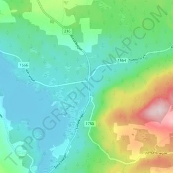
Name: Arneberg topographic map, elevation, terrain.
Location: Arneberg, Ringsaker, Innlandet, 2364, Norway (60.97650 10.77624 61.01650 10.81624)
Average elevation: 417 m
Minimum elevation: 327 m
Maximum elevation: 673 m
Thank you for supporting this site ❤️
Make a donation
Make a donation
Other topographic maps
Click on a map to view its topography, its elevation and its terrain.
Hamar
Hamar has a humid continental climate (Dfb) with fairly dry and cold winters, and comfortably warm summers. The Hamar II weather station, at an elevation of 141 metres (463 ft), started recording in 1968. The all-time high 33 °C (91 °F) was recorded in July 2018, which was the warmest month on record with…
Average elevation: 445 m