
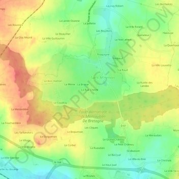
La Rue Chèvre topographic map
Interactive map
Click on the map to display elevation.
About this map
Name: La Rue Chèvre topographic map, elevation, terrain.
Average elevation: 93 m
Minimum elevation: 63 m
Maximum elevation: 121 m
Other topographic maps
Click on a map to view its topography, its elevation and its terrain.
La Brohinière
France > Bretagne > Ille-et-Vilaine > Montauban-de-Bretagne
La Brohinière, Montauban-de-Bretagne, Rennes, Ille-et-Vilaine, Bretagne, France métropolitaine, 35360, France
Average elevation: 93 m
La Hucherais
France > Bretagne > Ille-et-Vilaine > Montauban-de-Bretagne
La Hucherais, Montauban-de-Bretagne, Rennes, Ille-et-Vilaine, Bretagne, France métropolitaine, 35360, France
Average elevation: 77 m
Saint-M'Hervon
France > Bretagne > Ille-et-Vilaine > Montauban-de-Bretagne
Saint-M'Hervon, Montauban-de-Bretagne, Rennes, Ille-et-Vilaine, Bretagne, France métropolitaine, 35360, France
Average elevation: 92 m
La Haute Rouvrais
France > Bretagne > Ille-et-Vilaine > Montauban-de-Bretagne
La Haute Rouvrais, Montauban-de-Bretagne, Rennes, Ille-et-Vilaine, Bretagne, France métropolitaine, 35360, France
Average elevation: 84 m
Le Champ du Moulin
France > Bretagne > Ille-et-Vilaine > Montauban-de-Bretagne
Le Champ du Moulin, Montauban-de-Bretagne, Rennes, Ille-et-Vilaine, Bretagne, France métropolitaine, 35360, France
Average elevation: 83 m