
Thank you for supporting this site ❤️
Make a donation
Make a donation
Box Canyon topographic map
Click on the map to display elevation.
Thank you for supporting this site ❤️
Make a donation
Make a donation
About this map
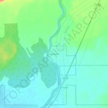
Name: Box Canyon topographic map, elevation, terrain.
Location: Box Canyon, Fremont County, Idaho, United States (44.35721 -111.42534 44.39721 -111.38534)
Average elevation: 1,891 m
Minimum elevation: 1,871 m
Maximum elevation: 1,948 m
Thank you for supporting this site ❤️
Make a donation
Make a donation
Other topographic maps
Click on a map to view its topography, its elevation and its terrain.
Newdale
United States > Idaho > Fremont County
Newdale is the nearest city to the Teton Dam, which failed on June 5, 1976. Newdale did not receive any flooding or damage, due to its elevation and position relative to the dam.
Average elevation: 1,550 m
Thank you for supporting this site ❤️
Make a donation
Make a donation
American Legion / Daughters of Utah Pioneers Park
United States > Idaho > Fremont County > St. Anthony
Average elevation: 1,515 m