
Thank you for supporting this site ❤️
Make a donation
Make a donation
Alborz Province topographic map
Click on the map to display elevation.
Thank you for supporting this site ❤️
Make a donation
Make a donation
About this map
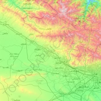
Name: Alborz Province topographic map, elevation, terrain.
Location: Alborz Province, Iran (35.52715 50.16315 36.35089 51.52528)
Average elevation: 1,756 m
Minimum elevation: 566 m
Maximum elevation: 4,790 m
Thank you for supporting this site ❤️
Make a donation
Make a donation
Other topographic maps
Click on a map to view its topography, its elevation and its terrain.
Baba Jan, East Azerbaijan
Iran > East Azerbaijan Province > Ahar County > دهستان قشلاق
Average elevation: 1,752 m
Thank you for supporting this site ❤️
Make a donation
Make a donation