
Make a donation
Paraná topographic map
Click on the map to display elevation.
Make a donation
Paraná
The state can be separated into five main topographic areas, from east to west: a coastal zone, the mountains of Serra do Mar, and then three plateaus, each lower than the other, until the Paraná River is reached.
Make a donation
About this map
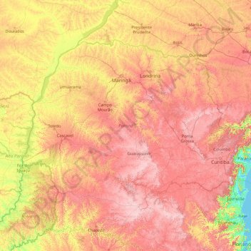
Name: Paraná topographic map, elevation, terrain.
Location: Paraná, South Region, Brazil (-26.72090 -54.61986 -22.51600 -47.85611)
Average elevation: 548 m
Minimum elevation: -1 m
Maximum elevation: 1,585 m
Make a donation
Other topographic maps
Click on a map to view its topography, its elevation and its terrain.
Brasília
Brazil > Federal District > Região Integrada de Desenvolvimento do Distrito Federal e Entorno
The city sits at an elevation of 1,000 metres (3,300 ft) and more, high on the Brazilian Highlands in the country's center-western region. Paranoá Lake, a large artificial lake, was built to increase the amount of water available and to maintain the region's humidity. It has a marina, and hosts wakeboarders…
Average elevation: 1,084 m
Região Metropolitana do Recife
Brazil > Pernambuco > Região Metropolitana do Recife > Cabo de Santo Agostinho
Average elevation: 119 m
Make a donation