
Make a donation
Berwick topographic map
Click on the map to display elevation.
Make a donation
Berwick
According to the United States Census Bureau, the town has a total area of 37.86 square miles (98.06 km2), of which, 37.52 square miles (97.18 km2) of it is land and 0.34 square miles (0.88 km2) is water. Berwick is drained by the Little River and Salmon Falls River. Diamond Hill, elevation 490 feet (149.4 m) above sea level, is the town's highest point. The lowest elevation, which is approximately 70 feet (21.3 m) above sea level, is on the Salmon River as it crosses the southernmost town border with South Berwick.
Make a donation
About this map
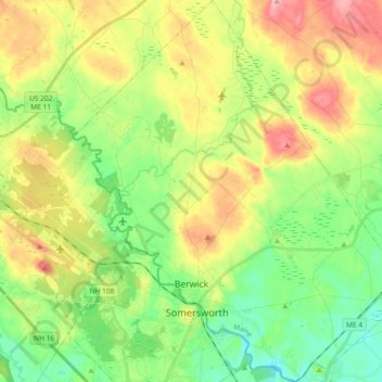
Name: Berwick topographic map, elevation, terrain.
Location: Berwick, York County, Maine, 03901, United States (43.23786 -70.92483 43.37245 -70.76040)
Average elevation: 76 m
Minimum elevation: 17 m
Maximum elevation: 165 m
Make a donation
Other topographic maps
Click on a map to view its topography, its elevation and its terrain.