
Thank you for supporting this site ❤️
Make a donation
Make a donation
Carbost topographic map
Click on the map to display elevation.
Thank you for supporting this site ❤️
Make a donation
Make a donation
About this map
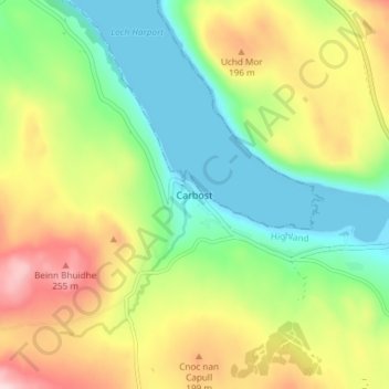
Name: Carbost topographic map, elevation, terrain.
Location: Carbost, Highland, Scotland, IV47 8SS, United Kingdom (57.28154 -6.37323 57.32154 -6.33323)
Average elevation: 110 m
Minimum elevation: 0 m
Maximum elevation: 277 m
Thank you for supporting this site ❤️
Make a donation
Make a donation
Other topographic maps
Click on a map to view its topography, its elevation and its terrain.
Eilean Donan
United Kingdom > Scotland > Highland > Dornie > Totaig
In 1689, King James VII of the House of Stuart was declared to have to forfeit the throne, and the crown was offered to William of Orange, in the so-called "Glorious Revolution". The revolution also established Presbyterianism in Scotland, although the Highlands generally remained Roman Catholic and loyal to…
Average elevation: 82 m
Thank you for supporting this site ❤️
Make a donation
Make a donation