
Naxos topographic map
Interactive map
Click on the map to display elevation.
About this map
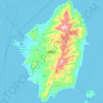
Name: Naxos topographic map, elevation, terrain.
Average elevation: 112 m
Minimum elevation: -1 m
Maximum elevation: 986 m
Other topographic maps
Click on a map to view its topography, its elevation and its terrain.
Amorgos
Griechenland > Ägäis > Regionalbezirk Naxos
Amorgos, Regionalbezirk Naxos, Region Südliche Ägäis, Ägäis, 840 08, Griechenland
Average elevation: 28 m