
Thank you for supporting this site ❤️
Make a donation
Make a donation
Concavada topographic map
Click on the map to display elevation.
Thank you for supporting this site ❤️
Make a donation
Make a donation
About this map
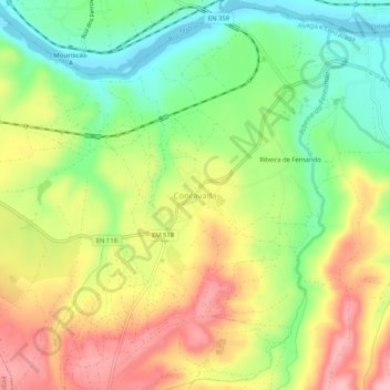
Name: Concavada topographic map, elevation, terrain.
Location: Concavada, Abrantes, Santarém, Portugal (39.43272 -8.08852 39.47272 -8.04852)
Average elevation: 96 m
Minimum elevation: 25 m
Maximum elevation: 177 m
Thank you for supporting this site ❤️
Make a donation
Make a donation
Other topographic maps
Click on a map to view its topography, its elevation and its terrain.
Thank you for supporting this site ❤️
Make a donation
Make a donation
Thank you for supporting this site ❤️
Make a donation
Make a donation