
Thank you for supporting this site ❤️
Make a donation
Make a donation
Hokianga Harbour topographic map
Click on the map to display elevation.
Thank you for supporting this site ❤️
Make a donation
Make a donation
About this map
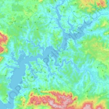
Name: Hokianga Harbour topographic map, elevation, terrain.
Average elevation: 113 m
Minimum elevation: -1 m
Maximum elevation: 755 m
Far North District trails, hiking, mountain biking, running and outdoor activities
Thank you for supporting this site ❤️
Make a donation
Make a donation
Other topographic maps
Click on a map to view its topography, its elevation and its terrain.
Whakawhiti Stream
New Zealand > Far North District > Bay of Islands-Whangaroa Community > Manawaora
Average elevation: 58 m
Whatuwhiwhi
New Zealand > Far North District > Te Hiku Community > Whatuwhiwhi
Average elevation: 18 m