
Thank you for supporting this site ❤️
Make a donation
Make a donation
Gaithersburg topographic map
Click on the map to display elevation.
Thank you for supporting this site ❤️
Make a donation
Make a donation
About this map
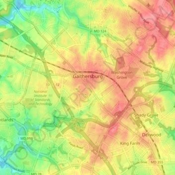
Name: Gaithersburg topographic map, elevation, terrain.
Location: Gaithersburg, Montgomery County, Maryland, United States (39.10275 -77.25827 39.16831 -77.17118)
Average elevation: 137 m
Minimum elevation: 93 m
Maximum elevation: 171 m
Thank you for supporting this site ❤️
Make a donation
Make a donation
Other topographic maps
Click on a map to view its topography, its elevation and its terrain.
Stoney Creek Pond
United States > Maryland > Montgomery County > Bethesda > Glenwood
Average elevation: 100 m