
Thank you for supporting this site ❤️
Make a donation
Make a donation
Accokeek topographic map
Click on the map to display elevation.
Thank you for supporting this site ❤️
Make a donation
Make a donation
Accokeek
According to the United States Census Bureau, the place has a total area of 28.803 square miles (74.60 km2), of which 27.436 square miles (71.06 km2) is land and 1.367 square miles (3.54 km2) is water. Accokeek has an average elevation of 194 feet (59 m).
Thank you for supporting this site ❤️
Make a donation
Make a donation
About this map
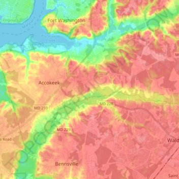
Name: Accokeek topographic map, elevation, terrain.
Location: Accokeek, Prince George's County, Maryland, United States (38.61618 -77.07793 38.70938 -76.91913)
Average elevation: 40 m
Minimum elevation: -3 m
Maximum elevation: 74 m
Thank you for supporting this site ❤️
Make a donation
Make a donation