
Town of Plum Lake topographic map
Interactive map
Click on the map to display elevation.
About this map
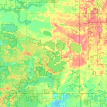
Name: Town of Plum Lake topographic map, elevation, terrain.
Location: Town of Plum Lake, Vilas County, Wisconsin, United States (45.98208 -89.61779 46.11265 -89.36704)
Average elevation: 518 m
Minimum elevation: 486 m
Maximum elevation: 570 m
Other topographic maps
Click on a map to view its topography, its elevation and its terrain.
Town of Lac du Flambeau
United States > Wisconsin > Vilas County
Town of Lac du Flambeau, Vilas County, Wisconsin, 54538, United States
Average elevation: 489 m
Rest Lake
United States > Wisconsin > Vilas County
Rest Lake, Town of Manitowish Waters, Vilas County, Wisconsin, United States
Average elevation: 492 m
Little Star Lake
United States > Wisconsin > Vilas County
Little Star Lake, Town of Plum Lake, Vilas County, Wisconsin, United States
Average elevation: 519 m
Town of Land O' Lakes
United States > Wisconsin > Vilas County
Town of Land O' Lakes, Vilas County, Wisconsin, 54540, United States
Average elevation: 520 m
Fawn Lake
United States > Wisconsin > Vilas County
Fawn Lake, Town of Saint Germain, Vilas County, Wisconsin, United States
Average elevation: 491 m
Town of Boulder Junction
United States > Wisconsin > Vilas County
Town of Boulder Junction, Vilas County, Wisconsin, 54512, United States
Average elevation: 505 m
Eagle River
United States > Wisconsin > Vilas County
Eagle River, Vilas County, Wisconsin, 54521, United States
Average elevation: 500 m
Weber Lake
United States > Wisconsin > Vilas County > Town of Phelps
Weber Lake, Town of Phelps, Vilas County, Wisconsin, United States
Average elevation: 543 m
Town of Conover
United States > Wisconsin > Vilas County
Town of Conover, Vilas County, Wisconsin, 54519, United States
Average elevation: 515 m
Mantowish Waters
United States > Wisconsin > Vilas County
Mantowish Waters, Town of Manitowish Waters, Vilas County, Wisconsin, 54545, United States
Average elevation: 491 m
Big Portage Lake
United States > Wisconsin > Vilas County
Big Portage Lake, Town of Land O' Lakes, Vilas County, Wisconsin, United States
Average elevation: 523 m
Trout Lake
United States > Wisconsin > Vilas County
Trout Lake, Town of Arbor Vitae, Vilas County, Wisconsin, United States
Average elevation: 502 m
Edith Lake
United States > Wisconsin > Vilas County
Edith Lake, Town of Presque Isle, Vilas County, Wisconsin, United States
Average elevation: 514 m
Presque Isle
United States > Wisconsin > Vilas County
Presque Isle, Town of Presque Isle, Vilas County, Wisconsin, 54557, United States
Average elevation: 508 m
Land O' Lakes
United States > Wisconsin > Vilas County > Land O' Lakes
Land O' Lakes, Town of Land O' Lakes, Vilas County, Wisconsin, United States
Average elevation: 524 m
Anvil Lake
United States > Wisconsin > Vilas County
Anvil Lake, Town of Washington, Vilas County, Wisconsin, United States
Average elevation: 529 m
Star Lake
United States > Wisconsin > Vilas County
Star Lake, Town of Plum Lake, Vilas County, Wisconsin, 54561, United States
Average elevation: 522 m
Town of Manitowish Waters
United States > Wisconsin > Vilas County
Town of Manitowish Waters, Vilas County, Wisconsin, 54545, United States
Average elevation: 491 m
Town of Phelps
United States > Wisconsin > Vilas County
Town of Phelps, Vilas County, Wisconsin, 54554, United States
Average elevation: 529 m
Broken Bow Lake
United States > Wisconsin > Vilas County > Town of Lac du Flambeau
Broken Bow Lake, Town of Lac du Flambeau, Vilas County, Wisconsin, United States
Average elevation: 493 m