
Thank you for supporting this site ❤️
Make a donation
Make a donation
Tirana County topographic map
Click on the map to display elevation.
Thank you for supporting this site ❤️
Make a donation
Make a donation
About this map
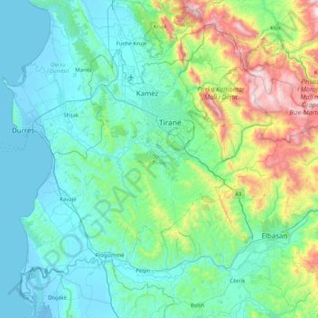
Name: Tirana County topographic map, elevation, terrain.
Location: Tirana County, Central Albania, Albania (40.99969 19.43649 41.51540 20.23995)
Average elevation: 317 m
Minimum elevation: -7 m
Maximum elevation: 1,815 m
Thank you for supporting this site ❤️
Make a donation
Make a donation
Other topographic maps
Click on a map to view its topography, its elevation and its terrain.
Liqeni i Farkës
Albania > Central Albania > Tirana County > Tirana Municipally > Mollasej (Farka e Vogël)
Average elevation: 195 m