
Thank you for supporting this site ❤️
Make a donation
Make a donation
Lantawan topographic map
Click on the map to display elevation.
Thank you for supporting this site ❤️
Make a donation
Make a donation
About this map
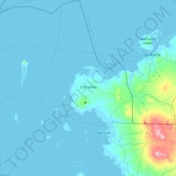
Name: Lantawan topographic map, elevation, terrain.
Location: Lantawan, Basilan, Bangsamoro, 7301, Philippines (6.45832 121.65583 6.81500 121.93018)
Average elevation: 59 m
Minimum elevation: -5 m
Maximum elevation: 851 m
Thank you for supporting this site ❤️
Make a donation
Make a donation
Other topographic maps
Click on a map to view its topography, its elevation and its terrain.