
Thank you for supporting this site ❤️
Make a donation
Make a donation
Crystal Lakes topographic map
Click on the map to display elevation.
Thank you for supporting this site ❤️
Make a donation
Make a donation
About this map
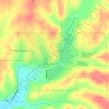
Name: Crystal Lakes topographic map, elevation, terrain.
Location: Crystal Lakes, Ray County, Missouri, United States (39.35273 -94.20181 39.37078 -94.17327)
Average elevation: 283 m
Minimum elevation: 241 m
Maximum elevation: 316 m
Thank you for supporting this site ❤️
Make a donation
Make a donation
Other topographic maps
Click on a map to view its topography, its elevation and its terrain.