
Thank you for supporting this site ❤️
Make a donation
Make a donation
Denholm topographic map
Click on the map to display elevation.
Thank you for supporting this site ❤️
Make a donation
Make a donation
About this map
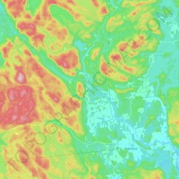
Name: Denholm topographic map, elevation, terrain.
Location: Denholm, La Vallée-de-la-Gatineau, Outaouais, Quebec, Canada (45.76934 -75.94785 45.90333 -75.72501)
Average elevation: 279 m
Minimum elevation: 162 m
Maximum elevation: 503 m
Thank you for supporting this site ❤️
Make a donation
Make a donation
Other topographic maps
Click on a map to view its topography, its elevation and its terrain.