Geolocate

Resort Municipality of Stanley Bridge, Hope River, Bayview, Cavendish and North Rustico topographic map

Interactive map

Click on the map to display elevation.

Resort Municipality of Stanley Bridge, Hope River, Bayview, Cavendish and North Rustico topographic map, elevation, terrain

Resort Municipality of Stanley Bridge, Hope River, Bayview, Cavendish and North Rustico topographic map, elevation, terrain

About this map

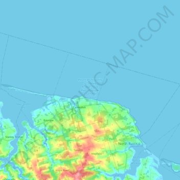
Name: Resort Municipality of Stanley Bridge, Hope River, Bayview, Cavendish and North Rustico topographic map, elevation, terrain.

Location: Resort Municipality of Stanley Bridge, Hope River, Bayview, Cavendish and North Rustico, Queens County, Prince Edward Island, Canada (46.45698 -63.48196 46.55632 -63.24575)

Average elevation: 10 m

Minimum elevation: -5 m

Maximum elevation: 100 m

Other topographic maps

Click on a map to view its topography, its elevation and its terrain.

Bear River South

Canada > Prince Edward Island > Lot 44

Average elevation: 53 m

Meadowbank

Canada > Prince Edward Island > Meadowbank

Average elevation: 13 m

Ellerslie

Canada > Prince Edward Island > Summerside > Ellerslie

Average elevation: 15 m