
Salles topographic map
Interactive map
Click on the map to display elevation.
About this map
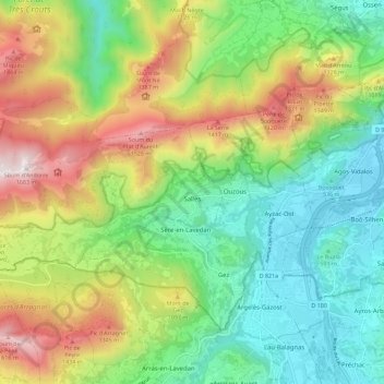
Name: Salles topographic map, elevation, terrain.
Average elevation: 859 m
Minimum elevation: 397 m
Maximum elevation: 1,668 m
Other topographic maps
Click on a map to view its topography, its elevation and its terrain.
Sère-en-Lavedan
França > Occitânia > Altos Pirineus
Sère-en-Lavedan, Argelès-Gazost, Altos Pirineus, Occitânia, França metropolitana, 65400, França
Average elevation: 742 m