Baltimore topographic map
Interactive map
Click on the map to display elevation.
About this map
![Baltimore topographic map, elevation, terrain](/pub/maps/relation/s49m/65zf3/thumbnail.jpg)
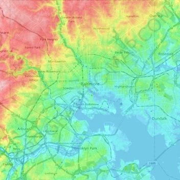
Name: Baltimore topographic map, elevation, terrain.
Location: Baltimore, Maryland, United States (39.19723 -76.71130 39.37200 -76.52968)
Average elevation: 47 m
Minimum elevation: -4 m
Maximum elevation: 158 m
Baltimore is in north-central Maryland on the Patapsco River close to where it empties into the Chesapeake Bay. The city is also located on the fall line between the Piedmont Plateau and the Atlantic coastal plain, which divides Baltimore into "lower city" and "upper city". The city's elevation ranges from sea level at the harbor to 480 feet (150 m) in the northwest corner near Pimlico.
Other topographic maps
Click on a map to view its topography, its elevation and its terrain.
![Contee topographic map, elevation, terrain](/pub/maps/node/7mb3/mgqg151/icon.jpg)
Contee
United States > Maryland > Prince George's County > South Laurel
Contee, South Laurel, Prince George's County, Maryland, 20811, United States
Average elevation: 65 m
![Clinton topographic map, elevation, terrain](/pub/maps/relation/r2tj/dbvs8/icon.jpg)
Clinton
United States > Maryland > Prince George's County > Clinton
Clinton, Prince George's County, Maryland, 20735, United States
Average elevation: 64 m
![Fairmount Heights topographic map, elevation, terrain](/pub/maps/relation/6s3l/9z2tf/icon.jpg)
Fairmount Heights
United States > Maryland > Prince George's County
Fairmount Heights, Prince George's County, Maryland, United States
Average elevation: 30 m
![Spencerville topographic map, elevation, terrain](/pub/maps/node/3tnh/xnpsq3l/icon.jpg)
Spencerville
United States > Maryland > Montgomery County
Spencerville, Montgomery County, Maryland, 20868, United States
Average elevation: 144 m
![Amberly topographic map, elevation, terrain](/pub/maps/node/dnnh/z3s6lnx/icon.jpg)
Amberly
United States > Maryland > Anne Arundel County
Amberly, Anne Arundel County, Maryland, 21409, United States
Average elevation: 8 m
![Idlewilde topographic map, elevation, terrain](/pub/maps/node/jj57/sqsb8gt/icon.jpg)
Idlewilde
United States > Maryland > Anne Arundel County > Shady Side
Idlewilde, Shady Side, Anne Arundel County, Maryland, 20764, United States
Average elevation: 0 m
![Garrett County topographic map, elevation, terrain](/pub/maps/relation/66z4/7jc9t6/icon.jpg)
Garrett County
Garrett County, Maryland, United States
Average elevation: 700 m
![Piscataway Hills topographic map, elevation, terrain](/pub/maps/node/7mb3/xn4w63l/icon.jpg)
Piscataway Hills
United States > Maryland > Prince George's County > Fort Washington
Piscataway Hills, Fort Washington, Prince George's County, Maryland, 20607, United States
Average elevation: 26 m
![Arnold Heights topographic map, elevation, terrain](/pub/maps/node/3h14/hxgdkrr/icon.jpg)
Arnold Heights
United States > Maryland > Prince George's County > Suitland
Arnold Heights, Suitland, Prince George's County, Maryland, 20395, United States
Average elevation: 79 m
![University Park topographic map, elevation, terrain](/pub/maps/relation/7ltf/jnhnx/icon.jpg)
University Park
United States > Maryland > Prince George's County
University Park, Prince George's County, Maryland, United States
Average elevation: 29 m
![Brunswick topographic map, elevation, terrain](/pub/maps/relation/mrgp/2mhtj/icon.jpg)
Brunswick
United States > Maryland > Frederick County
Brunswick, Frederick County, Maryland, United States
Average elevation: 118 m
![Havre de Grace topographic map, elevation, terrain](/pub/maps/relation/skz4/65mb3/icon.jpg)
Havre de Grace
United States > Maryland > Harford County
Havre de Grace, Harford County, Maryland, 21078, United States
Average elevation: 24 m
![Chestertown topographic map, elevation, terrain](/pub/maps/relation/l69m/65pf3/icon.jpg)
Chestertown
United States > Maryland > Chestertown
Chestertown, Kent County, Maryland, 21620, United States
Average elevation: 11 m
![Blenhiem Run topographic map, elevation, terrain](/pub/maps/way/k5kl/hhk95gtp/icon.jpg)
Blenhiem Run
United States > Maryland > Harford County > Havre de Grace
Blenhiem Run, Havre de Grace, Harford County, Maryland, 21078, United States
Average elevation: 55 m
![Stoney Creek Pond topographic map, elevation, terrain](/pub/maps/way/ntrr/5jd9kgt/icon.jpg)
Stoney Creek Pond
United States > Maryland > Montgomery County > Bethesda > Glenwood
Stoney Creek Pond, Battery Lane, Glenwood, Bethesda, Montgomery County, Maryland, United States
Average elevation: 100 m
![Capitol Heights topographic map, elevation, terrain](/pub/maps/node/31s8/kvkgrb3/icon.jpg)
Capitol Heights
United States > Maryland > Prince George's County > Capitol Heights > Capitol Heights
Capitol Heights, Prince George's County, Maryland, 20743, United States
Average elevation: 51 m
![Charles County topographic map, elevation, terrain](/pub/maps/relation/h6rr/hd76tp/icon.jpg)
Charles County
United States > Maryland > Charles County
Charles County, Maryland, United States
Average elevation: 27 m
![Calvert County topographic map, elevation, terrain](/pub/maps/relation/hdrr/hd7dtp/icon.jpg)
Calvert County
United States > Maryland > Calvert County
Calvert County, Maryland, United States
Average elevation: 18 m
![Accokeek topographic map, elevation, terrain](/pub/maps/relation/6xzs/pfqm2/icon.jpg)
Accokeek
United States > Maryland > Prince George's County > Accokeek
Accokeek, Prince George's County, Maryland, United States
Average elevation: 40 m
![Howard County topographic map, elevation, terrain](/pub/maps/relation/3kdn/8kxk9m/icon.jpg)
Howard County
United States > Maryland > Howard County
Howard County, Maryland, United States
Average elevation: 128 m
![Columbia topographic map, elevation, terrain](/pub/maps/relation/l79m/65hf3/icon.jpg)
Columbia
United States > Maryland > Howard County > Columbia
Columbia, Howard County, Maryland, United States
Average elevation: 114 m
![Wilde Lake topographic map, elevation, terrain](/pub/maps/way/1zs/89gqqmt/icon.jpg)
Wilde Lake
United States > Maryland > Howard County > Columbia
Wilde Lake, Bryant Woods, Wilde Lake, Columbia, Howard County, Maryland, United States
Average elevation: 114 m
![White Oak topographic map, elevation, terrain](/pub/maps/relation/88gp/2m7tj/icon.jpg)
White Oak
United States > Maryland > Montgomery County > White Oak
White Oak, Montgomery County, Maryland, United States
Average elevation: 101 m
![Gaithersburg topographic map, elevation, terrain](/pub/maps/relation/fw18/18j3q/icon.jpg)
Gaithersburg
United States > Maryland > Montgomery County
Gaithersburg, Montgomery County, Maryland, United States
Average elevation: 137 m
![Olney topographic map, elevation, terrain](/pub/maps/relation/wj57/tljrr/icon.jpg)
Olney
United States > Maryland > Montgomery County > Olney
Olney, Montgomery County, Maryland, United States
Average elevation: 136 m
![Hagerstown topographic map, elevation, terrain](/pub/maps/relation/nsrr/hd251/icon.jpg)
Hagerstown
United States > Maryland > Hagerstown
Hagerstown, Washington County, Maryland, United States
Average elevation: 170 m
![Frederick topographic map, elevation, terrain](/pub/maps/relation/sn9m/65bf3/icon.jpg)
Frederick
United States > Maryland > Frederick
Frederick, Frederick County, Maryland, United States
Average elevation: 105 m
![Annapolis topographic map, elevation, terrain](/pub/maps/relation/msmt/sx2nh/icon.jpg)
Annapolis
United States > Maryland > Annapolis
Annapolis, Anne Arundel County, Maryland, United States
Average elevation: 8 m
![Bethesda topographic map, elevation, terrain](/pub/maps/relation/ffs8/sxz1h/icon.jpg)
Bethesda
United States > Maryland > Montgomery County > Bethesda
Bethesda, Montgomery County, Maryland, United States
Average elevation: 81 m
![Silver Spring topographic map, elevation, terrain](/pub/maps/relation/ff18/18k3q/icon.jpg)
Silver Spring
United States > Maryland > Montgomery County > Silver Spring
Silver Spring, Montgomery County, Maryland, United States
Average elevation: 86 m
![Towson topographic map, elevation, terrain](/pub/maps/relation/mz14/dd8ggt/icon.jpg)
Towson
United States > Maryland > Baltimore County > Towson
Towson, Baltimore County, Maryland, United States
Average elevation: 114 m
![Harmans topographic map, elevation, terrain](/pub/maps/node/k51h/dr6hlz4/icon.jpg)
Harmans
United States > Maryland > Harmans
Harmans, Anne Arundel County, Maryland, 21077, United States
Average elevation: 44 m