
Launceston topographic map
Interactive map
Click on the map to display elevation.
About this map
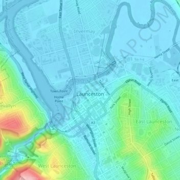
Name: Launceston topographic map, elevation, terrain.
Location: Launceston, City of Launceston, Tasmania, 7250, Australia (-41.45043 147.12699 -41.41633 147.16079)
Average elevation: 26 m
Minimum elevation: -6 m
Maximum elevation: 166 m
Launceston is at 41°26′31″S 147°8′42″E / 41.44194°S 147.14500°E / -41.44194; 147.14500 in the Tamar Valley, Northern Tasmania. The valley was formed by volcanic and glacial forces over 10 million years ago. The city is about 45 kilometres (28 mi) south of the Bass Strait, with its closest neighbour-city being Devonport, about 99 kilometres (62 mi) to the north west. Launceston combines steep (originally heavily wooded) ridges and low-lying areas (originally wetlands – with parts of the suburbs of Inveresk and Invermay below high-tide level). As a result, areas of Launceston are subject to landslip problems, while others are liable to poor drainage and periodic flooding. The topography of the area is not conducive to easy dispersion of airborne pollution, due to the phenomenon of thermal inversion.
Other topographic maps
Click on a map to view its topography, its elevation and its terrain.
Mount Lloyd
Mount Lloyd, Derwent Valley, Tasmania, 7140, Australia
Average elevation: 558 m
Curtis Island
Curtis Island, Flinders Council, Tasmania, Australia
Average elevation: 18 m
Cataract Gorge Reserve
Australia > Tasmania > Launceston
Cataract Gorge Reserve, Launceston, City of Launceston, Tasmania, 7250, Australia
Average elevation: 125 m
Dove Lake
Australia > Tasmania > Cradle Mountain
Dove Lake, Cradle Mountain, Kentish, Tasmania, Australia
Average elevation: 1,060 m
Queenstown
Queenstown, West Coast, Tasmania, 7467, Australia
Average elevation: 330 m
Legana
Australia > Tasmania > Launceston > Legana
Legana, Launceston, West Tamar, Tasmania, Australia
Average elevation: 82 m
Mount Wellington
Mount Wellington, City of Hobart, Tasmania, Australia
Average elevation: 941 m
King Island Council
King Island Council, Tasmania, Australia
Average elevation: 14 m
Binalong Bay
Australia > Tasmania > Binalong Bay
Binalong Bay, Tasmania, Australia
Average elevation: 23 m
Lake McRae
Lake McRae, Overland Track, Tasmania, Australia
Average elevation: 1,044 m
Lake Dobson
Lake Dobson, Pandani Grove Nature Walk, Tasmania, Australia
Average elevation: 1,093 m
Lake Margaret
Australia > Tasmania > Lake Margaret
Lake Margaret, Tasmania, Australia
Average elevation: 436 m
Blythe River
Blythe River, Burnie, Tasmania, 7320, Australia
Average elevation: 99 m