
Make a donation
Norway topographic map
Click on the map to display elevation.
Make a donation
Norway
Norway's topography is defined by its rugged and varied terrain, shaped by ancient geological processes and glacial activity. Dominating the landscape are the Scandinavian Mountains, which run through the country and include peaks like Galdhøpiggen, the highest in Northern Europe at 2,469 meters (8,100 feet). These mountains descend sharply to the west, forming the dramatic fjords for which Norway is renowned, such as the Sognefjord, the world's second deepest fjord. In contrast, the eastern regions feature more gradual slopes leading to expansive valleys and plateaus. The Hardangervidda plateau, for instance, is Europe's largest mountain plateau, characterized by its barren, treeless moorlands and numerous lakes. Glacial erosion has left a significant mark on the terrain, carving out deep valleys and leaving behind numerous glaciers, especially in the western part of the country. This diverse and dramatic landscape not only defines Norway's natural beauty but also influences its climate, biodiversity, and human activities.
Make a donation
About this map
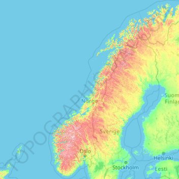
Name: Norway topographic map, elevation, terrain.
Location: Norway (57.75901 4.08753 71.38488 31.76149)
Average elevation: 143 m
Minimum elevation: -3 m
Maximum elevation: 2,267 m
Make a donation
Other topographic maps
Click on a map to view its topography, its elevation and its terrain.
Make a donation
Make a donation
Make a donation
Pulpit Rock
The walk to Preikestolen is very steep in places. The path starts at the Preikestolhytta, at an elevation of approximately 270 metres (890 ft) above sea level, and climbs to 604 metres (1,982 ft). The walk takes 2–3 hours depending on traffic along the trail, experience, and fitness level. Even though the…
Average elevation: 289 m
Make a donation
Make a donation
Trondheim
Trondheim is situated where the River Nidelva meets Trondheim Fjord with an excellent harbour and sheltered condition. The river used to be deep enough for most boats in the Middle Ages. An avalanche of mud and stones made it less navigable and partly ruined the harbour in the mid-17th century. The…
Average elevation: 118 m
Make a donation
Make a donation
Make a donation
Bodø - Bådåddjo
Snow cover during winter varies, and is often sparse or lacking in the city center, while being more reliable only slightly inland or at some altitude. The largest recorded snow depth at the airport is 90 centimetres (35 in) in February 1976. Located on a peninsula in the Norwegian Sea, Bodø is known to be a…
Average elevation: 74 m
Make a donation
Make a donation
Make a donation
Make a donation
Make a donation
Make a donation
Make a donation
Make a donation
Make a donation
Make a donation
Make a donation
Make a donation
Make a donation
Make a donation
Make a donation
Make a donation
Make a donation