
Thank you for supporting this site ❤️
Make a donation
Make a donation
Castelo Rodrigo topographic map
Click on the map to display elevation.
Thank you for supporting this site ❤️
Make a donation
Make a donation
About this map
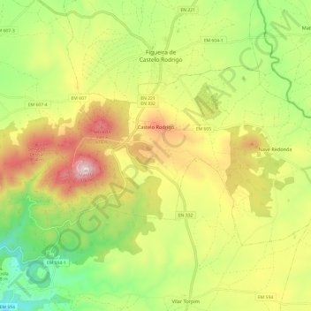
Name: Castelo Rodrigo topographic map, elevation, terrain.
Location: Castelo Rodrigo, Figueira de Castelo Rodrigo, Guarda, Portugal (40.84207 -6.99945 40.89459 -6.87931)
Average elevation: 648 m
Minimum elevation: 379 m
Maximum elevation: 974 m
Thank you for supporting this site ❤️
Make a donation
Make a donation
Other topographic maps
Click on a map to view its topography, its elevation and its terrain.