
Thank you for supporting this site ❤️
Make a donation
Make a donation
Cape Flattery topographic map
Click on the map to display elevation.
Thank you for supporting this site ❤️
Make a donation
Make a donation
About this map
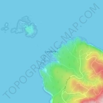
Name: Cape Flattery topographic map, elevation, terrain.
Location: Cape Flattery, Clallam County, Washington, United States (48.38591 -124.72696 48.38601 -124.72686)
Average elevation: 33 m
Minimum elevation: -5 m
Maximum elevation: 237 m
Thank you for supporting this site ❤️
Make a donation
Make a donation
Other topographic maps
Click on a map to view its topography, its elevation and its terrain.