
Thank you for supporting this site ❤️
Make a donation
Make a donation
Laughlin topographic map
Click on the map to display elevation.
Thank you for supporting this site ❤️
Make a donation
Make a donation
About this map
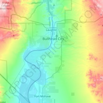
Name: Laughlin topographic map, elevation, terrain.
Location: Laughlin, Clark County, Nevada, United States (35.03580 -114.85324 35.20171 -114.56933)
Average elevation: 403 m
Minimum elevation: 145 m
Maximum elevation: 1,055 m
Thank you for supporting this site ❤️
Make a donation
Make a donation
Other topographic maps
Click on a map to view its topography, its elevation and its terrain.
Cougar Creek Park
United States > Nevada > Clark County > Las Vegas > Enterprise
Average elevation: 771 m
Thank you for supporting this site ❤️
Make a donation
Make a donation