
Pittsfield Charter Township topographic map
Interactive map
Click on the map to display elevation.
About this map
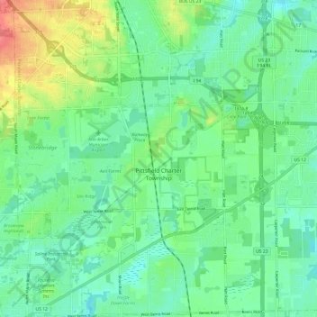
Name: Pittsfield Charter Township topographic map, elevation, terrain.
Average elevation: 256 m
Minimum elevation: 236 m
Maximum elevation: 304 m
Other topographic maps
Click on a map to view its topography, its elevation and its terrain.
Ann Arbor
United States > Michigan > Washtenaw County
Ann Arbor, Washtenaw County, Michigan, United States
Average elevation: 268 m
Ypsilanti
United States > Michigan > Washtenaw County
Ypsilanti, Washtenaw County, Michigan, 48197, United States
Average elevation: 230 m
Freedom Township
United States > Michigan > Washtenaw County
Freedom Township, Washtenaw County, Michigan, United States
Average elevation: 290 m
Saline
United States > Michigan > Washtenaw County
Saline, Washtenaw County, Michigan, 48176, United States
Average elevation: 248 m
Bridgewater Township
United States > Michigan > Washtenaw County
Bridgewater Township, Washtenaw County, Michigan, United States
Average elevation: 268 m
Lodi Township
United States > Michigan > Washtenaw County
Lodi Township, Washtenaw County, Michigan, United States
Average elevation: 275 m
Ann Arbor Charter Township
United States > Michigan > Washtenaw County
Ann Arbor Charter Township, Washtenaw County, Michigan, 48107, United States
Average elevation: 269 m
Ypsilanti Charter Township
United States > Michigan > Washtenaw County
Ypsilanti Charter Township, Washtenaw County, Michigan, 48198, United States
Average elevation: 228 m
Truman Lake
United States > Michigan > Washtenaw County > Saline Township
Truman Lake, Saline Township, Washtenaw County, Michigan, United States
Average elevation: 263 m
Blind Lake
United States > Michigan > Washtenaw County > Lyndon Township
Blind Lake, Lyndon Township, Washtenaw County, Michigan, United States
Average elevation: 276 m
Dexter
United States > Michigan > Washtenaw County > Dexter
Dexter, Washtenaw County, Michigan, United States
Average elevation: 270 m
Manchester
United States > Michigan > Washtenaw County
Manchester, Manchester Township, Washtenaw County, Michigan, United States
Average elevation: 283 m
Salem Township
United States > Michigan > Washtenaw County > Salem Township
Salem Township, Washtenaw County, Michigan, 48175, United States
Average elevation: 283 m
Augusta Township
United States > Michigan > Washtenaw County
Augusta Township, Washtenaw County, Michigan, 48191, United States
Average elevation: 209 m
Milan
United States > Michigan > Washtenaw County
Milan, Washtenaw County, Michigan, 48160, United States
Average elevation: 213 m
Fourmile Lake
United States > Michigan > Washtenaw County > Lima Township
Fourmile Lake, Lima Township, Washtenaw County, Michigan, 48118, United States
Average elevation: 275 m
Dexter Township
United States > Michigan > Washtenaw County
Dexter Township, Washtenaw County, Michigan, United States
Average elevation: 278 m