
Bolney topographic map
Click on the map to display elevation.
About this map
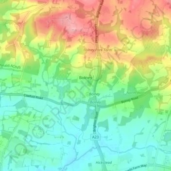
Name: Bolney topographic map, elevation, terrain.
Location: Bolney, Mid Sussex, West Sussex, England, United Kingdom (50.96832 -0.24202 51.01781 -0.17958)
Average elevation: 52 m
Minimum elevation: 9 m
Maximum elevation: 125 m
Other topographic maps
Click on a map to view its topography, its elevation and its terrain.
Felbridge
United Kingdom > England > West Sussex > Mid Sussex > East Grinstead
Average elevation: 98 m
Ardingly Reservoir
United Kingdom > England > West Sussex > Mid Sussex > Ardingly
Average elevation: 98 m
Henry Burt Wood
United Kingdom > England > West Sussex > Mid Sussex > Burgess Hill
Average elevation: 39 m
Worth Abbey
United Kingdom > England > West Sussex > Mid Sussex > Turners Hill
Average elevation: 124 m
Brook Street
United Kingdom > England > West Sussex > Mid Sussex > Whitemans Green
Average elevation: 76 m
Twineham Green
United Kingdom > England > West Sussex > Mid Sussex > Hickstead > Twineham Green
Average elevation: 21 m