
Thank you for supporting this site ❤️
Make a donation
Make a donation
North Washington topographic map
Click on the map to display elevation.
Thank you for supporting this site ❤️
Make a donation
Make a donation
About this map
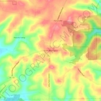
Name: North Washington topographic map, elevation, terrain.
Average elevation: 430 m
Minimum elevation: 375 m
Maximum elevation: 469 m
Thank you for supporting this site ❤️
Make a donation
Make a donation
Other topographic maps
Click on a map to view its topography, its elevation and its terrain.
Thank you for supporting this site ❤️
Make a donation
Make a donation
Zelienople
United States > Pennsylvania > Butler County
Zelienople is located in southwestern Butler County, situated on the south bank of Connoquenessing Creek, in an area that is rich with coal and iron ore. The elevation is 935 feet (285 m) above sea level. The borough is bordered by Jackson Township on the north, southeast, and south, and by the borough of…
Average elevation: 305 m
Thank you for supporting this site ❤️
Make a donation
Make a donation
Thank you for supporting this site ❤️
Make a donation
Make a donation
Thank you for supporting this site ❤️
Make a donation
Make a donation
Thank you for supporting this site ❤️
Make a donation
Make a donation
Butler Farm Show Lake
United States > Pennsylvania > Butler County > Meridian
Average elevation: 392 m
Thank you for supporting this site ❤️
Make a donation
Make a donation