
Thank you for supporting this site ❤️
Make a donation
Make a donation
Cuyapo topographic map
Click on the map to display elevation.
Thank you for supporting this site ❤️
Make a donation
Make a donation
About this map
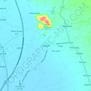
Name: Cuyapo topographic map, elevation, terrain.
Location: Cuyapo, Nueva Ecija, Central Luzon, 3117, Philippines (15.73749 120.62228 15.81749 120.70228)
Average elevation: 34 m
Minimum elevation: 18 m
Maximum elevation: 220 m
Thank you for supporting this site ❤️
Make a donation
Make a donation
Other topographic maps
Click on a map to view its topography, its elevation and its terrain.
Talavera
The municipality's terrain is relatively flat, with slope ranging from 0 to 3%. Due to the flat topography, the land is suited for agricultural, commercial or industrial development. It is bordered by Cabanatuan, Llanera, Muñoz, Aliaga, General Mamerto Natividad, Santo Domingo and San Jose.
Average elevation: 49 m
Thank you for supporting this site ❤️
Make a donation
Make a donation