
Mulbarton topographic map
Click on the map to display elevation.
About this map
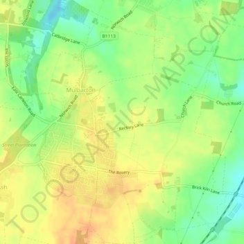
Name: Mulbarton topographic map, elevation, terrain.
Location: Mulbarton, South Norfolk, Norfolk, England, United Kingdom (52.54658 1.22306 52.57439 1.26183)
Average elevation: 41 m
Minimum elevation: 21 m
Maximum elevation: 55 m
Other topographic maps
Click on a map to view its topography, its elevation and its terrain.
Poringland Wood
United Kingdom > England > Norfolk > South Norfolk > Framingham Earl
Average elevation: 50 m
Fundenhall
United Kingdom > England > Norfolk > South Norfolk > Ashwellthorpe and Fundenhall
Average elevation: 50 m
Highoak
United Kingdom > England > Norfolk > South Norfolk > Morley St Botolph
Average elevation: 47 m
Beckhithe
United Kingdom > England > Norfolk > South Norfolk > Little Melton > Beckhithe
Average elevation: 37 m
Forncett Saint Mary
United Kingdom > England > Norfolk > South Norfolk > Forncett St Peter
Average elevation: 43 m