
Make a donation
Kearny topographic map
Click on the map to display elevation.
Make a donation
Kearny
The town is varied in topography and roughly divided into three parts: the Kearny Uplands, the Kearny Meadows and South Kearny, where the Hackensack and Passaic rivers meet. Main thoroughfares include the eponymous Kearny Avenue (the local segment of Ridge Road / Frank E. Rodgers Boulevard), Bergen Avenue, Midland Avenue, Schuyler Avenue and Passaic Avenue.
Make a donation
About this map
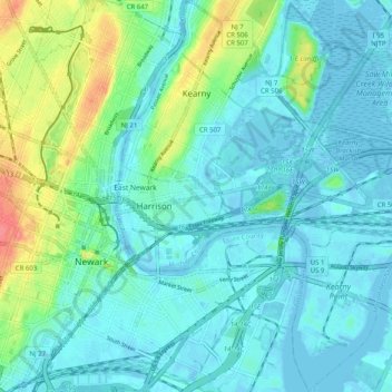
Name: Kearny topographic map, elevation, terrain.
Location: Kearny, Hudson County, New Jersey, 07032, United States (40.71060 -74.16475 40.78649 -74.07475)
Average elevation: 14 m
Minimum elevation: -6 m
Maximum elevation: 65 m
Make a donation
Other topographic maps
Click on a map to view its topography, its elevation and its terrain.
Croxton
United States > New Jersey > Hudson County > Jersey City > Journal Square
Average elevation: 16 m
Make a donation
North Hudson Park
United States > New Jersey > Hudson County > North Bergen > Hudson Heights
Average elevation: 41 m
Ellis Island
United States > New Jersey > Hudson County > Jersey City > Communipaw
The first floor contained detention rooms, social service offices, and waiting rooms on its west wing, a use that remained relatively unchanged. The central space was initially a baggage room until 1907, but was subsequently subdivided and later re-combined into a single records room. The first floor's east…
Average elevation: 1 m
Make a donation
Bergen Square
United States > New Jersey > Hudson County > Jersey City > Journal Square
Average elevation: 13 m
Marion
United States > New Jersey > Hudson County > Jersey City > Journal Square
Average elevation: 12 m
Make a donation
Make a donation
Croxton
United States > New Jersey > Hudson County > Jersey City > Journal Square
Average elevation: 16 m
Hudson River Waterfront
United States > New Jersey > Hudson County > Jersey City
Average elevation: 2 m
North End Business District
United States > New Jersey > Hudson County > Secaucus
Average elevation: 4 m
Bergen Square
United States > New Jersey > Hudson County > Jersey City > Journal Square
Average elevation: 13 m
Make a donation