
Make a donation
Haflong topographic map
Click on the map to display elevation.
Make a donation
About this map
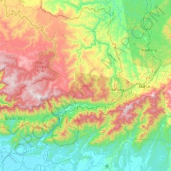
Name: Haflong topographic map, elevation, terrain.
Location: Haflong, Dima Hasao district, Assam, India (25.00055 92.52051 25.36443 93.15428)
Average elevation: 576 m
Minimum elevation: 13 m
Maximum elevation: 1,698 m
Make a donation
Other topographic maps
Click on a map to view its topography, its elevation and its terrain.
Make a donation
Make a donation
Make a donation
Dhemaji
Dhemaji is located at 27°29′N 94°35′E / 27.48°N 94.58°E / 27.48; 94.58. It has an average elevation of 91 metres (298 feet). Dhemaji is located to the north of the river Brahmaputra. To its north lies the Arunachal Himalayas. To its east lies the state, Arunachal Pradesh and to the west is…
Average elevation: 102 m
Make a donation
Make a donation
Rongpharbi Rongbe;Diphu
India > Assam > Diphu > Rongpharbi Rongbe;Diphu
Diphu is located at 25°50′N 93°26′E / 25.83°N 93.43°E / 25.83; 93.43. It has an average elevation of 186 metres (610 feet). It is about 270 km by road and 213 km by railways from Guwahati. The town is located on a beautiful hill.
Average elevation: 192 m
Make a donation
Make a donation
Udalguri
India > Assam > Udalguri tehsil
Odalguri is located at 26°44′43″N 92°05′46″E / 26.7452°N 92.0962°E / 26.7452; 92.0962. It has an average elevation of 180 metres (590 ft).
Average elevation: 109 m