
Κάλυμνος topographic map
Interactive map
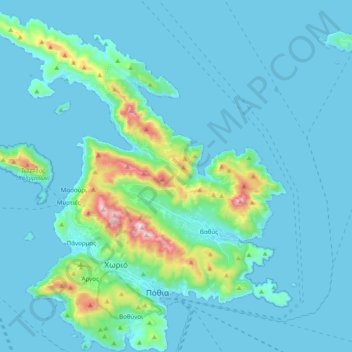
Click on the map to display elevation.
About this map
Name: Κάλυμνος topographic map, elevation, terrain.
Average elevation: 75 m
Minimum elevation: 0 m
Maximum elevation: 658 m
Aufgrund der Topografie und des Wassermangels war die Landwirtschaft der Insel nie besonders ausgeprägt. Die landwirtschaftlichen Flächen liegen in den Tälern von Vathy und Pothia und auf der Hochebene bei Argos. In geringerem Umfang auch bei Panormos und um die Dörfer Skalia und Emborios. Die einzige bedeutende landwirtschaftliche Fläche liegt im Tal von Vathi. Auf 1.500 Hektar werden Zitrusfrüchte erzeugt und auf mehr als 100 Hektar Freilandgemüse. Gemüsekulturen werden zunehmend in Folienhäusern kultiviert. Die produzierten Mengen erfüllen die lokalen Bedürfnisse nicht, die Versorgungslücke wird mit Einfuhren vor allem aus Kos aber auch aus Athen geschlossen. Um das Dorf Argos werden Oliven und Wein angebaut.
Other topographic maps
Click on a map to view its topography, its elevation and its terrain.
Patmos
Griechenland > Ägäis > Regionalbezirk Kalymnos > Skala
Patmos, Skala, Gemeinde Patmos, Regionalbezirk Kalymnos, Region Südliche Ägäis, Ägäis, 855 00, Griechenland
Average elevation: 15 m
Κάλυμνος
Griechenland > Ägäis > Regionalbezirk Kalymnos > Κάλυμνος
Κάλυμνος, Δήμος Καλυμνίων, Regionalbezirk Kalymnos, Region Südliche Ägäis, Ägäis, 85200, Griechenland
Average elevation: 133 m