
Rushford Village topographic map
Interactive map
Click on the map to display elevation.
About this map
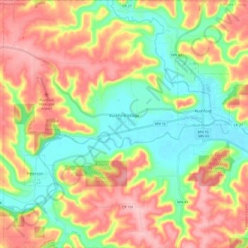
Name: Rushford Village topographic map, elevation, terrain.
Location: Rushford Village, Fillmore County, Minnesota, United States (43.76003 -91.85034 43.84706 -91.73032)
Average elevation: 299 m
Minimum elevation: 215 m
Maximum elevation: 390 m
Other topographic maps
Click on a map to view its topography, its elevation and its terrain.
Mabel
United States > Minnesota > Fillmore County
Mabel, Fillmore County, Minnesota, 55954, United States
Average elevation: 350 m
Fountain
United States > Minnesota > Fillmore County
Fountain, Fillmore County, Minnesota, United States
Average elevation: 387 m
Peterson
United States > Minnesota > Fillmore County
Peterson, Fillmore County, Minnesota, 55962, United States
Average elevation: 268 m
Spring Valley
United States > Minnesota > Fillmore County
Spring Valley, Fillmore County, Minnesota, United States
Average elevation: 400 m
Whalan
United States > Minnesota > Fillmore County
Whalan, Fillmore County, Minnesota, United States
Average elevation: 284 m
Wykoff
United States > Minnesota > Fillmore County
Wykoff, Fillmore County, Minnesota, 55990, United States
Average elevation: 398 m
Chatfield
United States > Minnesota > Fillmore County
Chatfield, Fillmore County, Minnesota, 55923, United States
Average elevation: 327 m
Canton
United States > Minnesota > Fillmore County
Canton, Fillmore County, Minnesota, United States
Average elevation: 403 m
Ostrander
United States > Minnesota > Fillmore County
Ostrander, Fillmore County, Minnesota, United States
Average elevation: 407 m
Lanesboro
United States > Minnesota > Fillmore County
Lanesboro, Fillmore County, Minnesota, 55949, United States
Average elevation: 299 m
Preston
United States > Minnesota > Fillmore County
Preston, Fillmore County, Minnesota, 55965, United States
Average elevation: 319 m
Rushford
United States > Minnesota > Fillmore County
Rushford, Fillmore County, Minnesota, 55971, United States
Average elevation: 255 m
Harmony
United States > Minnesota > Fillmore County
Harmony, Fillmore County, Minnesota, 55939, United States
Average elevation: 404 m
Chatfield
United States > Minnesota > Fillmore County
Chatfield, Fillmore County, Minnesota, 55923, United States
Average elevation: 327 m