Montgomery topographic map
Click on the map to display elevation.
Montgomery
Montgomery is located at 32°21′42″N 86°16′45″W / 32.36167°N 86.27917°W / 32.36167; -86.27917. According to the U.S. Census Bureau, the city has a total area of 156.2 square miles (405 km2), of which 155.4 square miles (402 km2) is land and 0.8 square miles (2.1 km2) (0.52%) is water. The city is built over rolling terrain at an elevation of about 220 feet (67 m) above sea level.
About this map
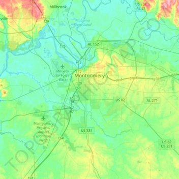
Name: Montgomery topographic map, elevation, terrain.
Location: Montgomery, Montgomery County, Alabama, United States (32.25055 -86.44301 32.43787 -86.06917)
Average elevation: 66 m
Minimum elevation: 37 m
Maximum elevation: 168 m
Other topographic maps
Click on a map to view its topography, its elevation and its terrain.




Woodmere Park
United States > Alabama > Montgomery County > Montgomery > Bellwood Plantation
Average elevation: 84 m




Ramer
United States > Alabama > Montgomery County
Ramer, also known as Athens, is an unincorporated community located in Montgomery County, Alabama, United States. The elevation is 469 feet (143 m). The community is located 23.9 miles (38.5 km) from the city of Montgomery.
Average elevation: 136 m


Greater Washington Park
United States > Alabama > Montgomery County > Montgomery
Average elevation: 53 m
Mountain View Estates
United States > Alabama > Montgomery County > Montgomery
Average elevation: 80 m