
Thank you for supporting this site ❤️
Make a donation
Make a donation
Altidona topographic map
Click on the map to display elevation.
Thank you for supporting this site ❤️
Make a donation
Make a donation
About this map
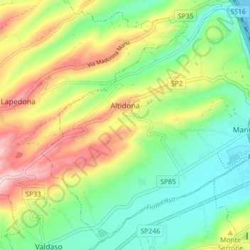
Name: Altidona topographic map, elevation, terrain.
Location: Altidona, Fermo, Marche, 63824, Italy (43.08407 13.77890 43.12717 13.84192)
Average elevation: 110 m
Minimum elevation: -4 m
Maximum elevation: 287 m
Thank you for supporting this site ❤️
Make a donation
Make a donation
Other topographic maps
Click on a map to view its topography, its elevation and its terrain.